Date:
Location:
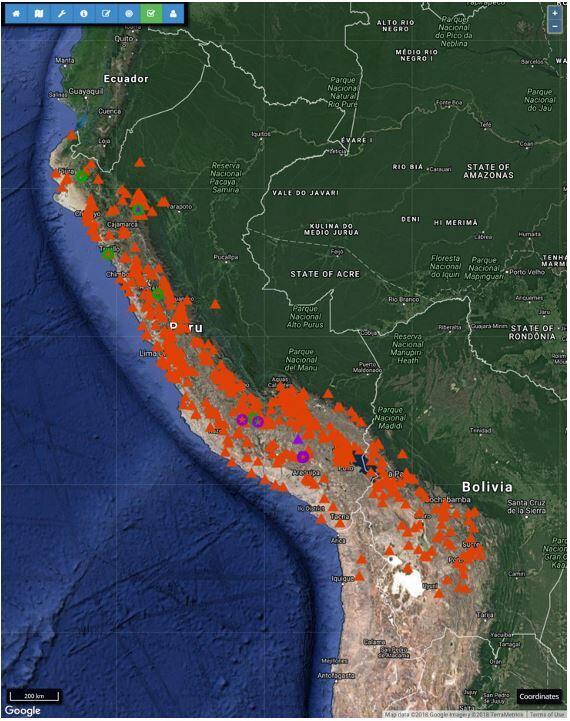
Archaeological field methods, including excavation and regional survey, are well suited to telling detailed, place-based stories, but they have significant drawbacks as means for characterizing the diversity of (and drivers of variation within) large, interregional systems. Even when data from multiple regional projects can be integrated, their distribution tends to be arbitrary, and so archaeologists' generalizations about large scale systems (such as empires and expansive states) often rest on shaky ground. Systematic surveys of larger scale datasets, including high resolution satellite imagery, may allow us to collect more extensive and consistent data from some types of sites and landscapes and also provide a basis for evaluating the representativity of existing regional and site-based datasets. The Geospatial Platform for Andean, Culture, History, and Archaeology, developed by Steven Wernke (Vanderbilt) and Parker VanValkenburgh (Brown), is our attempt to carry out this work within the Andes. In this talk, I discuss the project's federated approach, contrast it to other large-scale "virtual" survey projects, present preliminary results, and discuss the ethical challenges of conducting socially-distanced archaeology, at scale.

Parker VanValkenburgh is an anthropological archaeologist whose research focuses on understanding the political dimensions of urbanism, environmental change, and Indigenous identity, with a particular focus on the Andean region, since 1000 AD. He received his Ph.D. in 2012 from Harvard University and previously held positions at the University of Vermont (Assistant Prof. of Anthropology, 2013-15) and Washington University in St. Louis (Mellon Postdoctoral Fellow in Modeling Interdisciplinary Inquiry, 2012-13). Among other projects, he is currently director of the Paisajes Arqueológicos de Chachapoyas (PACha) project, an investigation of long-term human-environment interaction in Peru's Chachapoyas region, grounded in the analysis of archaeological survey, archival research, remotely sensed datasets, and work with contemporary communities in the provinces of Luya, Chachapoyas, and Bongará, Amazonas (Peru).
He is also a co-director, with Steven Wernke (Vanderbilt University), of GeoPACHA (Geospatial Platform for Andean Culture, HIstory and Archaeology); and, with Alicia Odewale (University of Tulsa) Mapping Historical Trauma in Tulsa, 1921-2021.

At Brown, he directs the Brown Digital Archaeology Laboratory and teaches courses on Geographic Information Systems, cartography, critical digital archaeology, the politics of space and landscape, historical anthropology, and the archaeology and anthropology of the Andean region. From 2008 to 2016, he directed the Proyecto Arqueológico Zaña Colonial, a project focusing on the impacts of Spanish colonial forced resettlement (reducción) on landscapes and political subjectivities in Peru’s North Coast region. Through the course of this research, he has become deeply invested in the use of digital-spatial technologies in archaeological research, particularly spatial analysis, mobile computing, and three-dimensional data capture and modeling. Two recent research collaborations with Brown University undergraduate students resulted in the following products - Socios en Patrimonio (2018) and Building a Tablet-Based Recording System for Archaeological Ceramic Classification (2016).
To Register, Click Here.